Sub-project (TP) 7
Project institute:
Rostock University, Faculty
of Agricultural and Environmental Sciences, Institute for Management of Rural
Areas, Professor of Geodesy und Geoinformatics
TP-Title:
Investigation of workflow
modelling in precision agriculture through the example of the construction of a
geodata infrastructure for precision farming
TP short title:
Geodata infrastructure for
Precision Farming
TP goals:
The first aim of the
sub-project is to produce a comprehensive model of all information-driven
site-specific business processes in precision farming. From this model, the
necessary data, metadata, data transfer standards and components for a geodata
infrastructure (GDI) supporting these processes will be identified, with
defined use cases implemented to illustrate how the GDI may be used in
practice.
Position of TP within the
network:
A close cooperation with
TP8 (Process documentation) and the other information management sub-projects
(TP17-19) is expected. TP8 will supply information on what data may be
automatically collected and aggregated. From TP17 comes the descriptions of an
organisation's data and from TP18 guidelines as to how the data may be used
within precision farming software. TP19 will specify the AgroXML standard,
which will be necessary for the configuration of the web-services. The GDI
designed within this sub-project will be implemented within the platform of the
project information system developed by TP22.
Research in the area of
information-driven plant production aims for the optimisation of farming
processes and organisations. Currently a major problem in this area is the
incompatibility between the various software systems in use. The result of this
project should therefore be to promote interoperability between software from
different vendors and to automate many data processing tasks. Most information
systems are based on a vertical architecture, with each system performing a
limited subset of tasks. The links between the systems, both within the farm
and between the farmer's and partners' and contractors' systems, are rarely
considered. Since it is likely that farmers will not adopt information-driven
precision farming effectively without the help and cooperation of service
providers and partners, integration in both directions is necessary. The data
integration should enable a consistent and transparent access method for the
heterogeneous datasets, as well as providing possibilities for new system-wide
applications. Alongside the integration of data, the integration of functions,
allowing applications to access functionality from other applications, is also
desirable. Once data and functions are accessible to all applications via a
common infrastructure, this will allow service-chaining to automate data
transfer and processing within precision agriculture businesses.
The overall aim of TP7 is
the creation of an information- and workflow-model describing all the necessary
agricultural processes. The focus of this model will not be on the structure of
the business, rather the value-adding processes such as the data-intensive
horticultural processes required for data-driven crop production. Which data
are required, or through these developments may be used, in which processes and
the interaction between agents will be analysed. From this analysis, a minimal
model of spatial data and metadata sufficient for precision farming will
follow. After the specification of which data are available and required under
which conditions, the use-cases for the processes in precision farming will be
modelled and the agents and their roles in these outlined (see example in Figure 1). From this modelling and analysis it will be
possible to begin specifying and building a geodata infrastructure for
precision farming (GDI-PF) supporting the identified use cases.
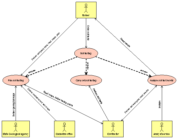
Figure 1 UML Diagram for the use-case
"Soil Testing"